El Niño reshuffles heat across the Pacific Ocean and into the atmosphere. This year’s super El Niño is landing on top of a much hotter world, amplifying climate impacts already being felt.
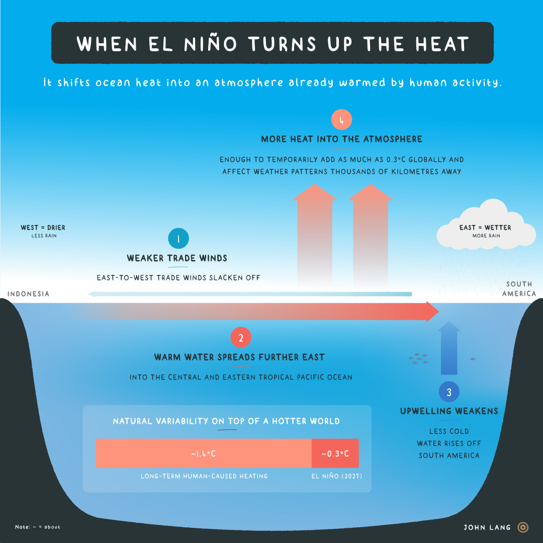
The basic idea is thus: El Niño is a natural climate pattern that periodically redirects heat across the tropical Pacific. Winds normally push warm surface water one way. During an El Niño, those winds weaken and the warm water moves back the other way.
Picture the Pacific in cross-section. Easterly trade winds – right to left above – normally push warm surface water west towards Indonesia. That movement allows colder, more nutrient-dense water from the deep ocean to ‘upwell’ off the coast of South America.
And during an El Niño?
That system weakens. The trade winds slacken off, allowing warm surface water to spread thousands of kilometres further east. That suppresses the normal upwelling off South America. And where warm water goes, the rain tends to follow – more evaporation means more convection and rainfall.
As the tropical Pacific releases more heat into the atmosphere, changes in tropical heat and rainfall affect atmospheric circulation, shifting weather patterns around the globe.
El Niño’s reach belies its origins as a patch of warmer-than-normal water in the Pacific. The reshuffling of the world's largest ocean–atmosphere system increases the odds of drought, floods, fires and extreme heat thousands of kilometres away. But El Niño isn't the bogeyman behind every climate impact. It’s a risk multiplier. El Niños do not produce the same weather patterns every time.
Think drought and fires in Indonesia, a weaker-than-normal Indian monsoon, failed harvests in southern Africa and flooding on the coasts of Peru and Ecuador. (Where the main impacts are likely to manifest is for a future Trunk visual.)
A whopper, even by El Niño standards
The latest forecasts put this super El Niño’s peak at around 4°C above the era-adjusted average in the central tropical Pacific, compared with the previous record of 2.75°C in 2015–16. The 2015–16 event was one of the strongest El Niños in recorded history. This one is forecast to blow it out of the water.
‘It looks like this year’s El Niño is not only very likely to be the strongest event since reliable records began – it may end up the strongest by a truly mind-blowing margin.’ — Zeke Hausfather, The Climate Brink
A strong El Niño raises the planet's average surface temperature, albeit temporarily. Based on the forecast strength of this one, the boost could be around 0.3°C, with the largest effect typically arriving about 3–5 months after El Niño conditions peak in the Pacific (usually around December).
That's why 2027 is likely to be record-shattering: Hausfather's latest forecast gives a 95%+ chance of 2027 topping the charts for the hottest year on record. Top of mind for policymakers should be food security: ‘Only El Niño can force globally synchronous crop failures’ because it simultaneously affects breadbasket growing regions on several continents.
Same temp, different world
Greenhouse gases add more energy to the climate system, whereas an El Niño shifts existing heat around. An El Niño boost in late 2026 and 2027 isn't the same as a future world that has settled at, for example, 1.75°C above pre-industrial temperatures.
The reading on the thermometer could look the same in 2027 as it does in 2037, but the impacts and underlying physics are different.
A temporary El Niño bump of between 0.2°C and 0.3°C is about equivalent to the long-term heating humans add every 10 years through burning coal, oil and gas.
El Niño heating will arrive and subside, whereas the fossil-fuelled heating it sits on accumulates as we add another 115 million tonnes of CO2 to the atmosphere every day.
To stop global temperatures rising, the world has to reach net zero CO2 emissions. That mostly means turning off the fossil-fuel tap and ending deforestation.